
Turn dashcam video into a repair plan for every kilometre of road.
Drive the road once with a phone or dashcam. Assurex Futureworks finds potholes, cracks, water ponding and missing signs, rates each one for severity and pins it to its chainage and GPS location. Your engineers see what to fix first.
Road networks have grown faster than the teams that inspect them.
Most condition surveys are still done by eye, written up by hand and filed as reports that are hard to search. That causes three problems for the engineers who plan repairs.
Surveys take weeks.
An engineer on foot can inspect only a few kilometres a day. By the time the register is typed up, the road has already changed.
Defects are hard to find again.
A note that says "near the culvert after the school" does not help a repair crew. The crew needs a chainage and a GPS point.
Repairs are hard to check.
There is rarely a dated photo of the same spot before and after the work, so it is hard to confirm what was fixed.
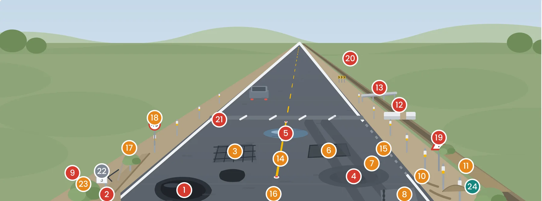
One drive checks the road for 24 kinds of defect and roadside asset.
Fix a phone or dashcam to any vehicle and drive at normal speed. The AI checks every video frame for the items below, in both directions, and gives each finding a priority from L1 critical to L4 low.
Pavement
- Potholes
- Edge breaking
- Alligator cracking
- Settlement and depressions
- Rutting
- Ravelling
- Failed patches
Drainage and shoulders
- Water ponding
- Blocked or silted side drains
- Edge drop-off
- Shoulder erosion and rain cuts
- Shoulder encroachment
Markings and safety
- Faded centre and edge lines
- Road studs
- Unmarked speed breakers
- Crash barriers
- Delineator posts
- Culvert parapets and railings
Signs and roadside
- Mandatory signs
- Cautionary signs
- Chevron signs on curves
- Kilometre stones
- Vegetation blocking the view
From road video to work order in four steps.
You do not need a special survey vehicle or new equipment. A survey starts with the phone in your pocket.
Record
Mount a phone or dashcam on the windscreen and drive the road at normal speed.
Detect
The AI finds each defect and asset in the video, measures its length or area and gives it a confidence score.
Locate
Each finding is stamped with its chainage, side of the road and GPS coordinates, so a crew can go straight to it.
Act
You get a road health score for every 500 metres, a priority for every defect and work orders for the urgent ones.
Engineers stay in charge. Findings with low confidence are marked Inspection Required, so an engineer checks them on site before anyone acts on them.
Every road in your circle, on your phone.
Officers see the roads they are responsible for. They can open any defect, find it on site and follow the repair until it is closed.
See where roads are getting worse
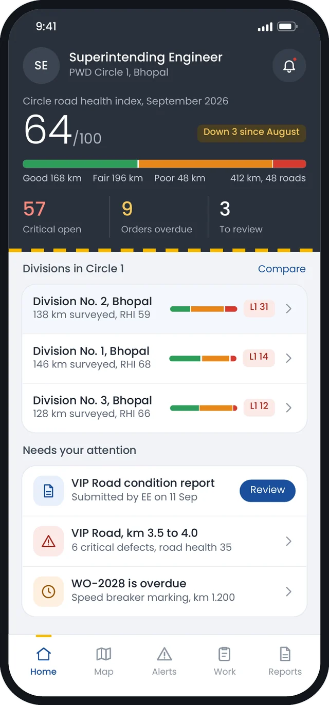
The home screen ranks each division by road health and shows critical defects and overdue work first.
Open any defect
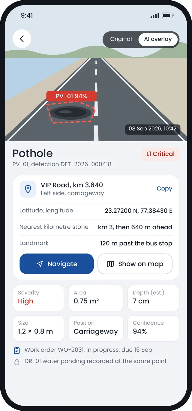
See the photo with the AI overlay, the size, the estimated depth and the nearest kilometre stone.
Find it on site
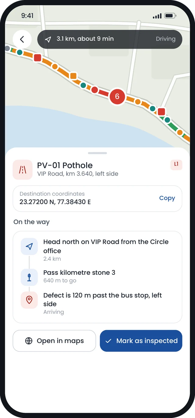
Get directions to the exact point on the road, then mark the defect as inspected.
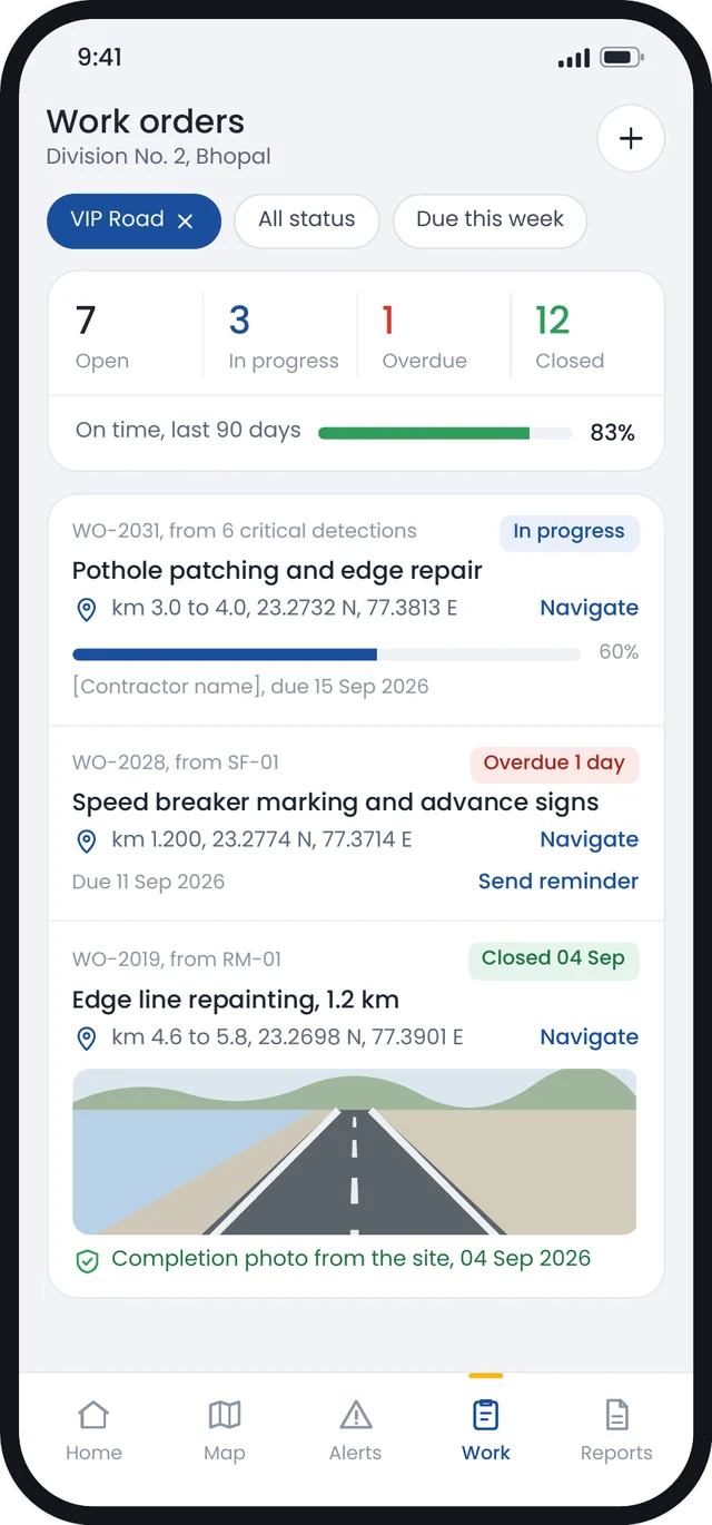
Follow the repair
Each work order shows its status, its due date and a completion photo from the site.
Concept screens of the Road Health Monitor app, shown with sample data.
A survey report your engineers can act on.
Each survey ends with a short report for the officer who asked for it. It shows where the road is failing, what to fix first and how to find each defect on site.
- A road health score for every 500 metre stretch, on a chart by chainage.
- A register of critical and high priority defects, each with its chainage and GPS coordinates.
- A suggested action for each priority level, from urgent repair to routine monitoring.
- A photo of each finding with the AI overlay.
- Downloads in PDF and Excel, plus a KML map file that opens in any map app.
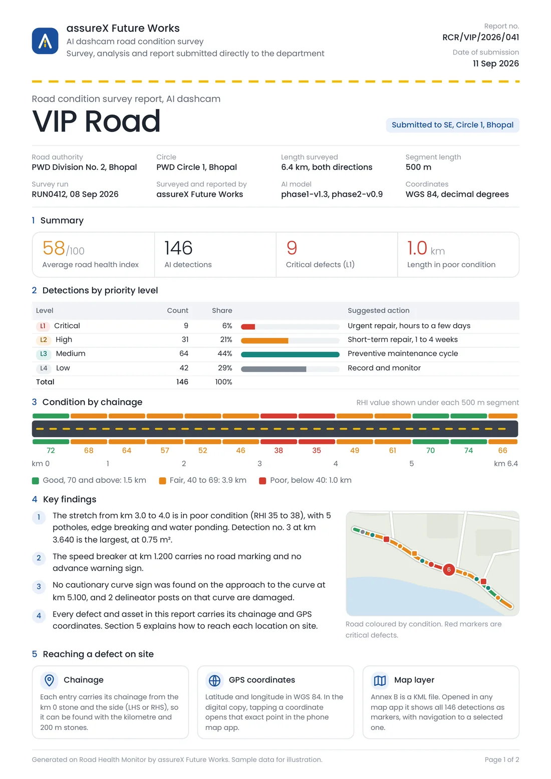
First page of a sample report. All names and figures are illustrative.
Road condition surveys come first. Three more modules follow.
All four modules use the same maps, chainage references and project records, so data from one stage of a road's life is ready for the next.
Road condition and assets
Map defects and roadside assets from phone or dashcam video. Get repair quantities, indicative costs and before and after checks of the repair work.
About road condition surveysConstruction progress monitoring
Compare drone surveys taken every 15 days with the approved programme, stage by stage, from earthwork to the final surface layer.
About construction monitoringDPR survey support
Turn drone and LiDAR surveys into terrain models, profiles, cross-sections and earthwork quantities for a Detailed Project Report.
About DPR supportSite intelligence for buildings and bridges
Compare site camera footage with the project's BIM model to see planned against actual progress for each work package.
About site intelligenceWho uses Assurex Futureworks.
Public Works Departments and road agencies
Know the condition of every road you manage, plan repairs by priority and check that the repairs were done.
Contractors
Keep a dated record of progress and quantities, linked to location, from the first survey to handover.
Consultants and supervision engineers
Get survey outputs for DPRs, regular progress records and a list of locations to inspect.
Government IT teams
Bring survey data into the systems you already use through dashboards, data exports and an API.
Made for Indian roads and the engineers who run them.
Trained on Indian roads
We develop our models on video of Indian roads and construction sites. Our data collection and labelling rules are set for local conditions.
Uses the codes you work with
Defect labels and severity ratings refer to Indian Roads Congress (IRC) codes, e.g., IRC:82 for the maintenance of bituminous roads.
Engineers make the decisions
The AI suggests a priority and a treatment. An engineer confirms it before a work order is raised.
Evidence for every finding
Every finding links to the photo and the location it came from, so anyone can check it.
See what one drive finds on your road.
We will walk you through a sample survey, from the video to the final report. We can also check whether road video you already have can be used.